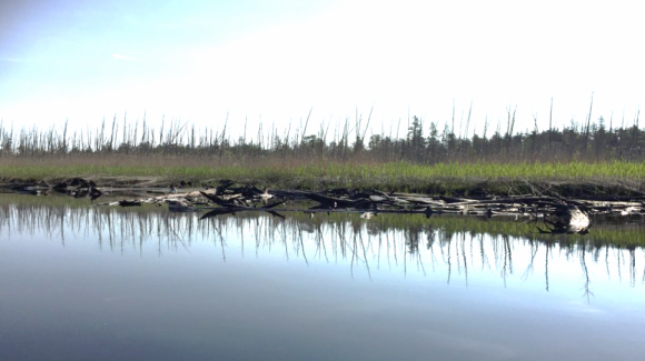
Standing dead tree trunks (a ghost forest) dominate this coastal landscape in New Jersey’s Mullica River watershed. Dead and down trunks from an earlier forest that was buried in marsh sediment are exposed along the water’s edge. Photo: Jennifer Walker
Higher groundwater levels from sea-level rise and increased flooding are likely the most important factors
Why are “ghost forests” filled with dead trees expanding along the mid-Atlantic and southern New England coast?
Higher groundwater levels linked to sea-level rise and increased flooding from storm surges and very high tides are likely the most important factors, according to a Rutgers study on the impacts of climate change that suggests how to enhance land-use planning.
“Strategic land conservation and restoration of coastal areas are critical to provide space for coastal forests and adjacent salt marshes to move inland as the sea level rises,” said co-author Richard G. Lathrop Jr., director of the Center for Remote Sensing & Spatial Analysis and a professor of environmental monitoring in the Department of Ecology, Evolution, and Natural Resources in the School of Environmental and Biological Sciences at Rutgers University–New Brunswick.
Coastal forests in the mid-Atlantic and southern New England (from Virginia through Massachusetts) have a mix of hardwoods and evergreen trees. They provide habitat for an array of rare plants and wildlife, store carbon and are valuable timber resources. Coastal forests along with adjacent salt marshes also help buffer inland areas from coastal storms. But sea-level rise is altering coastal forest ecosystems and “ghost forests” filled with dead trees are becoming a growing phenomenon in parts of the Northeast.
Working with the U.S. Department of Agriculture Northeast Climate Hub and in consultation with the U.S. Geological Survey New Jersey Water Science Center, Rutgers researchers assessed the latest information on how coastal forests in the Northeast are responding to climate change. The likely reasons for the death of coastal forests vary by location. But the most important factors appear to be: rising groundwater levels that saturate soils in low-lying areas, especially during periods of high rainfall, stressing forest vegetation; and increasing saltwater inundation from very high tides and storm surges. Accelerated sea-level rise is expected to worsen these impacts, which can leave areas inhospitable for trees.
Better land-use planning is needed to protect marsh or coastal forest ecosystems, the study says. For starters, forest and adjacent marsh ecosystems should be viewed as one unit when management plans are formed. Creating living shorelines to slow shoreline erosion; depositing dredged sediments to allow marshes to move higher in elevation as the sea level rises; and restoring tidal creek networks may help slow sea-level rise impacts. Promoting forest vegetation species that better tolerate changing conditions may be an option for some areas.
Most importantly, strategic land conservation and restoration of coastal areas are needed to provide space for coastal forests and salt marshes to move inland as the sea rises. Easements and property buyouts are critical to ensure enough space for them to migrate together.
More research is needed on how to manage coastal forests as they become stressed, how to reduce competition for space from a common invasive reed known as Phragmites australis and how to enhance tree and shrub regeneration. Regional mapping and modeling are needed to better understand the scope of dead forests and projected future hotspots – a task the Rutgers team will undertake in the coming year.
The lead author is Rachael Sacatelli, geographic information systems coordinator at the Center for Remote Sensing and Spatial Analysis at Rutgers University–New Brunswick. Senior author Marjorie Kaplan is associate director of the Rutgers Climate Institute.
This article originally was posted on Rutgers Today.

